Maja e Jezercës
Trip overview
Maja e Jezercës (Lake Mountain) with 2694 meters is the highest peak in Accursed Mountains situated on Montengro/Albanian border. It's located in pristine, wild and remote area. Therefore to reach the summit a long distance needs to be covered. Let me be clear, that is totaly worth it. This truly versatile trip will cater the most demanding mountain tastes. The diversity of landscape is truly massive and is what you could experience in couple different mountain trips combined. And all of that comes at relatively reasonable effort.
Trip starts in Vusanje with easy 5km of walk up Ropojanska Valley with slow rise of altitude which gives an opportunity to watch surrounding rocky giants. The effort goes up once the trail turns left and leads to Katun Zastan meadow. Now through the forest, at first steep and then with more even narrow path ending in opening of lakes basin in Buni E Jezerce valley. Here the path diverges, the right one goes a bit to the left and then straight to the hill in the centre. It continues up on the right side of the valley till a rocky threshold is reached. Here a more caution is needed because of the snow patch lying on the way. Whenever is possible it is advised to take the path through the rocks (path is marked). After snow is finally over the trail takes eastern direction from which it becomes a nice hiking effort. Above the pass between Maja Kokerhanes and Maja Jezerce the path goes south again and after about 100 meters terrain becomes demanding and requires head protection. In here marked well at all times. Path goes up and traverses in the western direction to avoid vertical north face. It becomes crumbly for about 100 meters of ascent to finally get us to the ridge along which another 200 meters of distance will get us to the peak.
Return path goes the same way (at least covered by this post) or the path to Albanian side can be taken. The route can be also modified to return directly to Ropojanska valley and give up Buni Jezerce valley on the way back. That will add to the overall distance and ascent values.
Trip conditions
Weather:
Sunny and mildly warm temperatures, from 5 degress celsius in the morning to 20 during the day
Trail:
Passable at all times, overall well marked in red colour, no securings
Additional information
Tips and author's comments:
No potable/running water available on the way. There are lakes and some snow that could possibly serve as water source but obviously needs to be disinfected. I've seen people camping next to the lakes on the way.
Crossing Montenegro/Albanian border which is needed to climb Maja Jezerce is theoretically illegal. No one controlled me on the way, nevertheless it is reasonable to hold a permit from border police.
A total of about 5 people met directly on the path. Some groups of people could be seen in Buni E Jezerce Valley.
Dangers:
Vipers (mind your steps in grassy passages), snow gaps, falling rocks, no phone signal in the valleys (which is for about 75% of the route)
Gear used:
Helmet, 20L rucksack, trekking poles, 10m of 7mm cord
Transportation:
Vusanje can be reached by car, on foot or hitchhiked. The nearest bus stop is in Gusinje.
Links:Parking location
Accommodation:
Guest house Kolata (10 EUR per night). Lots of tent fields available, also the free ones
Trip photos
 Ropojanska valley in the golden morning hour. It's going to be a long day but at least first kilometers are a leisure walk to warm-up before the real thing.
 Katun zastan is a home of shepherds and good sign that soon steep stretch of ascent through the forest will begin. Pay more attention here to trail marking it's faded occasionally.
 Opening of the Buni E Jezerce valley lake basin. You are now entering Albania but wouldn't know that from terrain as there are no border signs. The path drives left past the lake under the scree on the right to eventually climb that grassy threshold in the middle of picture. Maja e Jezercës is not visible from here, still a long way to go.
 Personally the most iconic view of the trip just above the threshold from previous picture. Path to Maja e Jezercës goes in southern direction.
 One hour later - second threshold climbed and the landscape changes drastically. Here path will start to meander and turn south-east and then east. Trail goes from one stony island to another and that's the most reasonable way to travel here.
  Be extremely careful at the edges and try to avoid walking on snow as much as possible.
 Finally there it is, far on the left side of the picture. Now you need to traverse a bit down to that long scree falling down and start approaching for the pass where there is no more snow.
 Except for crumbliness the scramble up won't give you big troubles. But yes, there are moments where you need to use 3 points to support yourself - thus I- grade. From here its about 30 minutes to reach the summit.
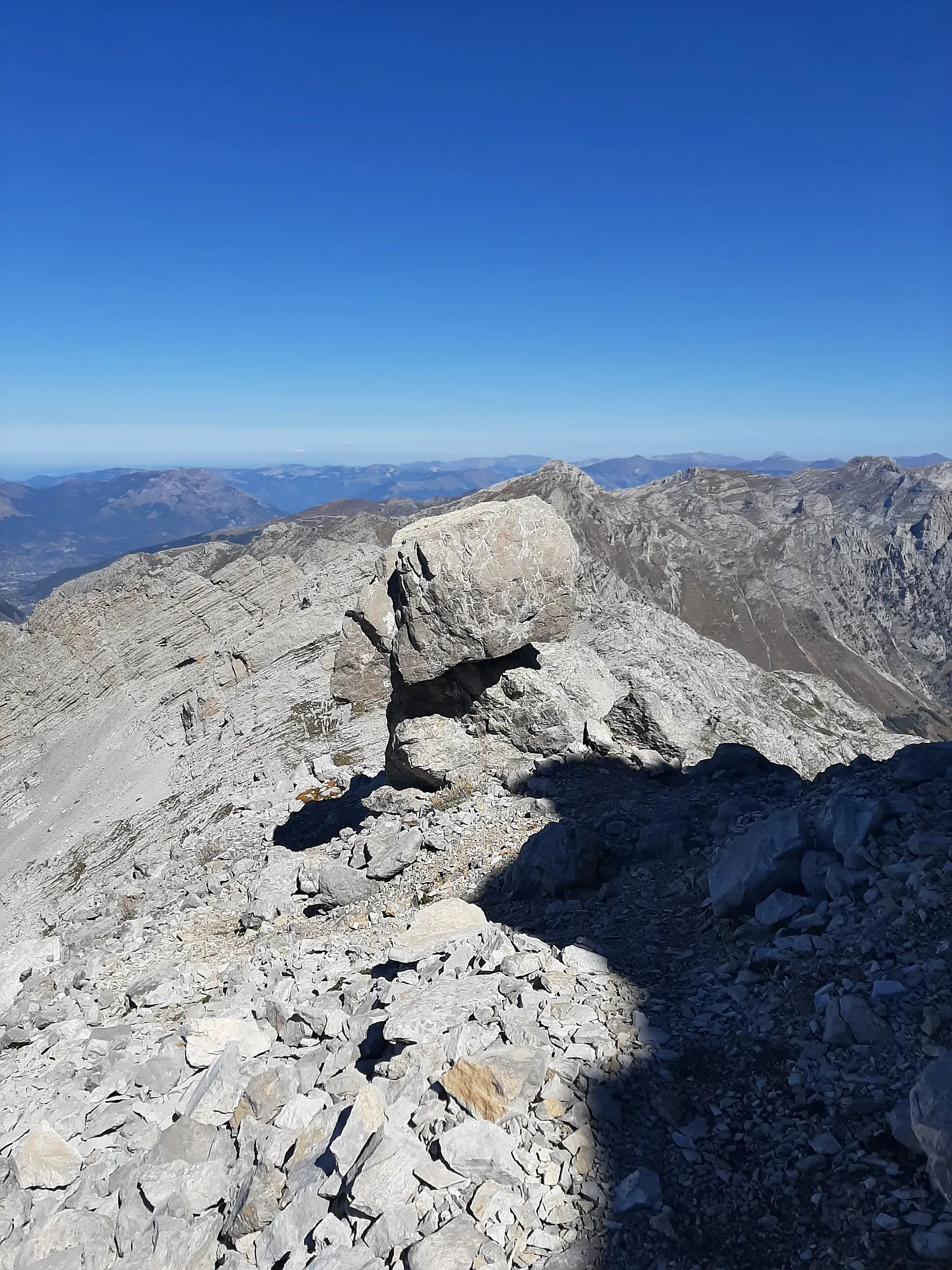 Conspicuous rocky mushroom, old marked trail used to go right from it, there is a bit risky descent. The new trail traverses that going down on the left and around to get to the right side.
 Ledge shelf quite typical for limestone and dolomite rock formation. Here serving as a traverse and pain in the butt to set a firm step.
 Last 100 meters up are not pleasant. Not that technically demanding but definetely annoying after all that effort to get here.
 Once on the ridge you will find your way. Maybe you will have some company but probably will stick to watch the views instead.
 Some eye candy on the way back. Face of Roman peak. You are almost there, congrats !