Škrlatica via south ridge
Trip overview
South ridge is a great and interesting way to climb Škrlatica. The route consists of 9 pitches and uses a system of chimneys, ramps, a few traverses, and less steep terrain. According to the authors of the route, the difficulties don't exceed IV- grade and that may be true to some extent. My personal experience was that I would rate one spot higher than even IV, and for the sections rated II-III I would sometimes go for IV grade.
Because of the predominant chimney formation, the route is theoretically easy to follow, though different variants are possible at the beginning of the route. There is no protection except for the pitons left in key moments; in different conditions, these are also available for rigging a belay stance.
This description covers only the climbing part. To learn more about the ascent and return route, refer to the via normale Škrlatica trip note.
Route description
Škrlatica south ridge (IV) access - marked trail to Škrlatica:
Starting from the parking lot we head in the direction of the Aljažev dom mountain hut and shortly before it we turn right into the trail that goes to Škrlatica. Now the fun part begins as the path is quite steep and exposed to the first rays of morning sun. We go past Bivak IV na Rušju shelter and continue on the marked trail. We need to leave the marked path at approximately 2,150 meters, just before the giant annoying scree between Škrlatica and Dolkova špica and traverse the south slabs in I-II terrain. The second terrace is the right one.
Škrlatica south ridge (IV) - route description:
The big picture is to stay on the left side of the ridge for 4 pitches from the start, cross the ridge (good belaying point in here), traverse a bit on the right side, back to the left, once again to the right, and with an airy traverse climb the last steep section. The last two pitches are in easier terrain. The climb takes around 4 hours.
A detailed description is as follows (big credits to Tomasz for providing details I would have otherwise missed). You can also refer to the topo, although it's not detailed enough.
The first pitch is about 54 - 55 meters; there are two pitons in the starting chimney. Next, a small wall follows with the possibility to set up a medium-sized friend. After the terrain eases off, choose the most approachable variant until a narrow chimney is reached with a cord belay stance.
The second pitch is a full 60 meters and starts again with a narrow, unpleasant chimney, continues with few difficulties, and finishes under a narrow chimney/corner. On the left side there is a piton not easily spotted at the start - then another piton, whereas on the right there is a fingertip crack that will nest a small friend nicely. (This section is quite vertical and personally proved to be the crux of the route). Once climbed, one can rig a stance just above this section or proceed up in easy terrain and take the first right gully. There is a belaying stance after almost 60 meters. It consists of a black piton and a lighter one; I used a tricam here as well.
The third pitch is 40 - 50 meters long with one more demanding section at the end of it - a small wall at the end of a deep chimney/gully. However, the rock offers a sling hole here and the belaying stance is just above with one piton (at eye level). I used two friends in here.
The fourth pitch is shorter, starts by bypassing a distinct rock on the left side and then turning right and going up a small wall (no protection) to the ridge. A sling belay is set on a crag rock horn.
The next pitch, the fifth, is a traverse for the key pitch, with two pitons on the way and two pitons in a sitting belay stance.
The sixth pitch is 60 meters. I did not climb the chimney but the edge of the pillar instead up to two visible pitons. One of them can be seen from the belay hammered half its length, the second one is just above. Next is a sling hole and another piton a bit above. Continue through a narrow ledge shelf to the left into a corner. Sling belay on a big rock.
The seventh pitch starts right from the belay into the corner (with a distinctly shaped rock formation); the corner goes up with a piton on the way. When the terrain eases off, I headed in the direction of the yellow wall looming from the top in between the rocks. Curved progression to the left, at the end - to the right into a corner. Sling belay at the mouth of the corner.
Eighth pitch - I climbed to a rust-colored wall and then to the right. The terrain eases off but is crumbly. It won't hurt to have some pitons to set up a belay as high as possible (full 60 meters).
The ninth pitch is also 60 meters long. Don't follow the right direction to a small pass, but use the chimneys (I used a big friend in here). Belay on a nondescript block just below the marked trail.
Škrlatica south ridge (IV) - route exit/descent (II/B):
The route finishes just above the recess in the ridge where the normal route to Škrlatica crosses it. There is around 300 vertical meters more to get to the peak using marked trail. To get down one need to get through the secured part (max B difficulty), then down the scree and eventually land back in the place where the marked trail was left. More details on this in dedicated post describing normal route to Škrlatica.
Trip conditions
Weather:
Cold at dawn (about 10 degrees), to warm temperatures on the ridge, no clouds and faint wind.
Trail:
Mostly good rock quality with occasional crumbliness and loose rocks (regarding only the climbing part). Terrain is more chossy in the upper part - last two pitches.
Additional information
Tips and author's comments:
The climbing part took me 4 hours in a two-person team.
It is reasonable to leave some of the stuff from the rucksack just before leaving the tourist trail as the way back goes the same way.
Dangers:
Occasional crumbliness requires double-checking most of the holds and steps. There are some easier sections with loose rocks on the way, these are easily triggered by a step or by a working rope.
Gear used:
30L rucksack, trekking poles, helmet, 60m rope, personal climbing set, 10 quickdraws (including alpine), set of friends, tricams, 5 pitons, hammer, slings, walkie-talkie set
Transportation:
The starting point can be reached by car. There's a parking lot just below Aljažev dom mountain hut. For more detailed information please refer to a dedicated section linked below.
Trip photos
 Topo for the route
 Škrlatica south ridge. Approximated course of the route.
 Start of the route in grassy spot.
 First pitch start with chimneys.
 Overhead belay stance for first pitch.
 Just above demanding section in second pitch with piton and cord to rig an intermediate belay stance.
 Terrain in third pitch.
 Small wall with no protection in fourth pitch just before reaching the ridge.
 Sling belay set on crag rock horn. Most fabuolous spot to belay.
 Fifth pitch means easy terrain, grassy and unlpeasant traverse and sitting belay stance.
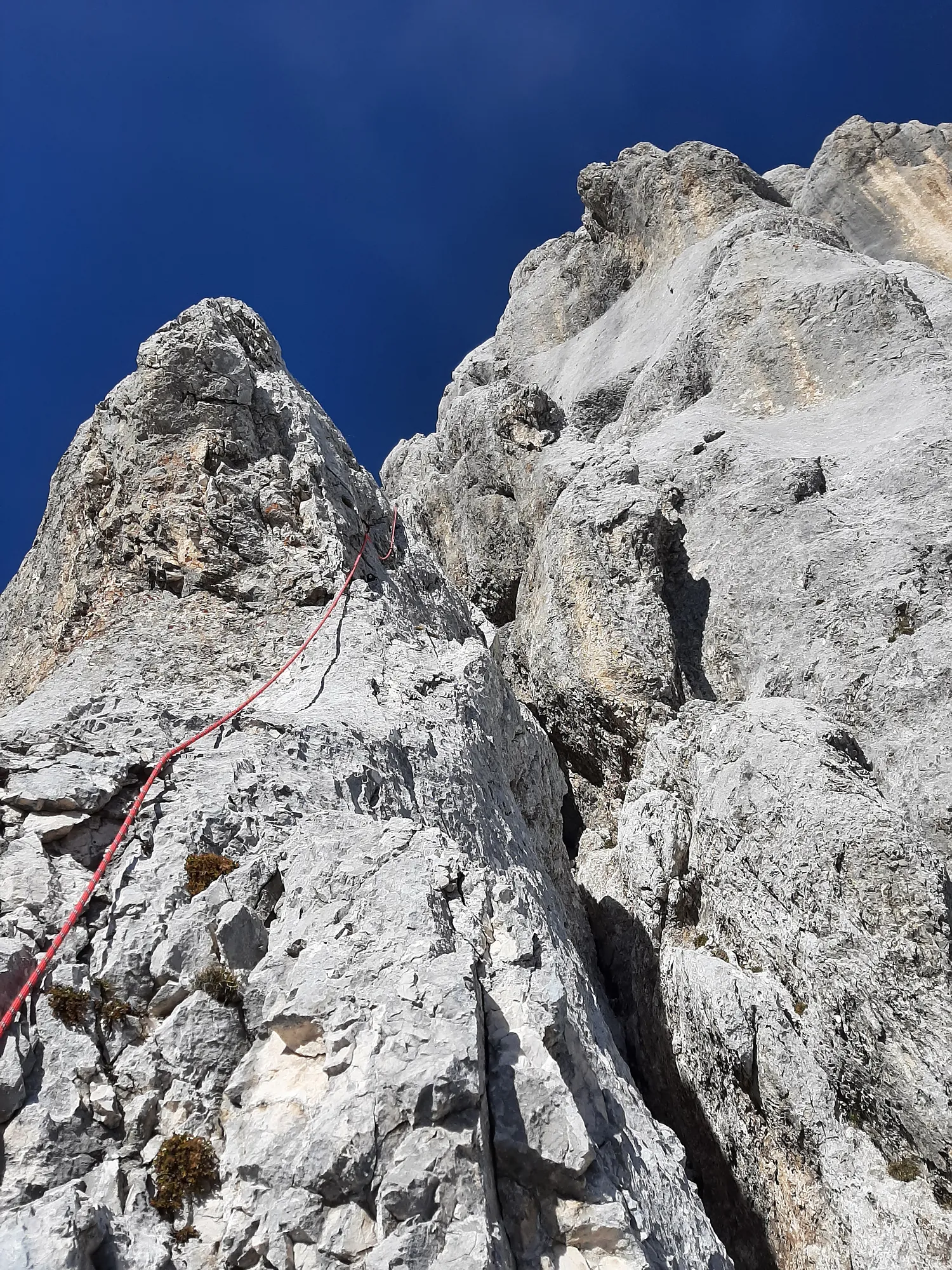 Start of crux of the route, rated -IV by the authors.
 Overhead belay for the sixth pitch. A bit of excitement waiting on that traverse marked with rope line.
 Same traverse as in previous photo but viewed from above.
 Terrain of seventh pitch, easy and enjoyable climbing!
 Last adrenaline shot in the route, secured with piton - this exposed traverse is iconic place indeed...
 ...above it there is only sun and chilled terrain (watch for loose rock though!). The belay stance marks the start of ninth pitch that finishes behind the rocks touching the sky. There it meets with tourist path.